|
|
|||||||||||||||||
| Point ID: 9019 | Downloads | Plots | Site Data | Code: 71206 |
|
|
|||||||||||||||||
| Download | |
|---|---|
| Site Descriptor Information | Site Time Series Data |
| Link to all available data | |
| View: | Time Series | All |
| Units: | mm |
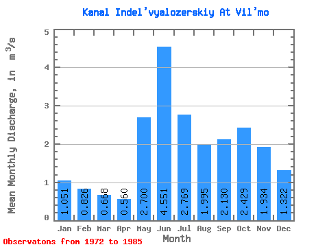
| Statistic | Jan | Feb | Mar | Apr | May | Jun | Jul | Aug | Sep | Oct | Nov | Dec | Annual |
|---|---|---|---|---|---|---|---|---|---|---|---|---|---|
| Mean | 1.05 | 0.83 | 0.67 | 0.56 | 2.70 | 4.55 | 2.77 | 2.00 | 2.13 | 2.43 | 1.93 | 1.32 | 1.92 |
| Standard Deviation | 0.74 | 0.71 | 0.62 | 0.52 | 1.68 | 1.24 | 0.94 | 0.91 | 1.13 | 1.09 | 1.06 | 0.92 | 0.54 |
| Min | 0.01 | 0.00 | 0.00 | 0.00 | 0.29 | 2.82 | 1.36 | 0.58 | 0.65 | 0.48 | 0.43 | 0.19 | 0.98 |
| Max | 2.10 | 2.04 | 1.73 | 1.51 | 5.22 | 7.49 | 4.15 | 3.76 | 4.54 | 4.29 | 4.24 | 2.88 | 2.70 |
| Coefficient of Variation | 0.70 | 0.86 | 0.93 | 0.93 | 0.62 | 0.27 | 0.34 | 0.46 | 0.53 | 0.45 | 0.55 | 0.69 | 0.28 |
 Return to R-Arctic Net Home Page