|
|
|||||||||||||||||
| Point ID: 8992 | Downloads | Plots | Site Data | Code: 71140 |
|
|
|||||||||||||||||
| Download | |
|---|---|
| Site Descriptor Information | Site Time Series Data |
| Link to all available data | |
| View: | Time Series | All |
| Units: | mm |
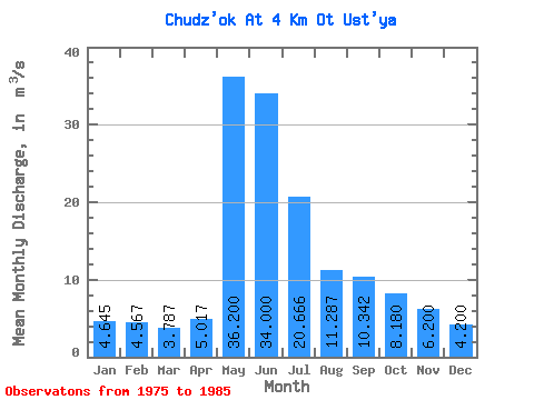
| Statistic | Jan | Feb | Mar | Apr | May | Jun | Jul | Aug | Sep | Oct | Nov | Dec | Annual |
|---|---|---|---|---|---|---|---|---|---|---|---|---|---|
| Mean | 4.64 | 4.57 | 3.79 | 5.02 | 36.20 | 34.00 | 20.67 | 11.29 | 10.34 | 8.18 | 6.20 | 4.20 | 15.21 |
| Standard Deviation | 1.56 | 1.18 | 1.34 | 2.78 | 23.85 | 10.57 | 8.79 | 4.64 | 4.73 | ||||
| Min | 3.54 | 3.34 | 2.55 | 2.86 | 9.10 | 25.40 | 9.16 | 3.78 | 3.84 | 8.18 | 6.20 | 4.20 | 15.21 |
| Max | 5.75 | 5.69 | 5.21 | 8.15 | 54.00 | 45.80 | 35.90 | 20.70 | 21.50 | 8.18 | 6.20 | 4.20 | 15.21 |
| Coefficient of Variation | 0.34 | 0.26 | 0.35 | 0.55 | 0.66 | 0.31 | 0.42 | 0.41 | 0.46 |
 Return to R-Arctic Net Home Page