|
|
|||||||||||||||||
| Point ID: 8990 | Downloads | Plots | Site Data | Code: 71135 |
|
|
|||||||||||||||||
| Download | |
|---|---|
| Site Descriptor Information | Site Time Series Data |
| Link to all available data | |
| View: | Time Series | All |
| Units: | mm |
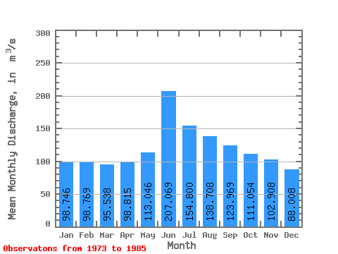
| Statistic | Jan | Feb | Mar | Apr | May | Jun | Jul | Aug | Sep | Oct | Nov | Dec | Annual |
|---|---|---|---|---|---|---|---|---|---|---|---|---|---|
| Mean | 98.75 | 98.77 | 95.54 | 98.81 | 113.05 | 207.07 | 154.80 | 138.71 | 123.97 | 111.05 | 102.91 | 88.01 | 119.29 |
| Standard Deviation | 20.45 | 22.82 | 21.01 | 27.32 | 32.07 | 102.29 | 84.69 | 38.10 | 42.01 | 31.00 | 26.16 | 21.40 | 22.77 |
| Min | 61.00 | 64.00 | 61.10 | 47.80 | 66.50 | 96.90 | 60.30 | 64.50 | 47.30 | 72.70 | 67.70 | 54.50 | 89.95 |
| Max | 129.00 | 133.00 | 124.00 | 137.00 | 166.00 | 490.00 | 325.00 | 205.00 | 199.00 | 164.00 | 168.00 | 117.00 | 161.27 |
| Coefficient of Variation | 0.21 | 0.23 | 0.22 | 0.28 | 0.28 | 0.49 | 0.55 | 0.28 | 0.34 | 0.28 | 0.25 | 0.24 | 0.19 |
 Return to R-Arctic Net Home Page