|
|
|||||||||||||||||
| Point ID: 8982 | Downloads | Plots | Site Data | Code: 71107 |
|
|
|||||||||||||||||
| Download | |
|---|---|
| Site Descriptor Information | Site Time Series Data |
| Link to all available data | |
| View: | Time Series | All |
| Units: | mm |
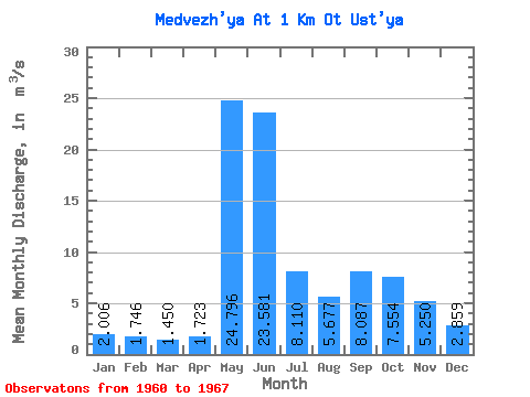
| Statistic | Jan | Feb | Mar | Apr | May | Jun | Jul | Aug | Sep | Oct | Nov | Dec | Annual |
|---|---|---|---|---|---|---|---|---|---|---|---|---|---|
| Mean | 2.01 | 1.75 | 1.45 | 1.72 | 24.80 | 23.58 | 8.11 | 5.68 | 8.09 | 7.55 | 5.25 | 2.86 | 8.34 |
| Standard Deviation | 0.52 | 0.23 | 0.20 | 0.55 | 11.86 | 15.02 | 3.25 | 3.65 | 3.17 | 3.55 | 1.78 | 0.89 | 0.66 |
| Min | 1.40 | 1.41 | 1.19 | 1.16 | 9.37 | 9.47 | 2.93 | 1.56 | 2.62 | 2.28 | 1.29 | 1.06 | 7.66 |
| Max | 3.07 | 2.16 | 1.77 | 2.68 | 39.10 | 47.50 | 13.20 | 11.70 | 13.20 | 11.90 | 6.46 | 3.78 | 9.18 |
| Coefficient of Variation | 0.26 | 0.13 | 0.14 | 0.32 | 0.48 | 0.64 | 0.40 | 0.64 | 0.39 | 0.47 | 0.34 | 0.31 | 0.08 |
 Return to R-Arctic Net Home Page