|
|
|||||||||||||||||
| Point ID: 8963 | Downloads | Plots | Site Data | Code: 71061 |
|
|
|||||||||||||||||
| Download | |
|---|---|
| Site Descriptor Information | Site Time Series Data |
| Link to all available data | |
| View: | Time Series | All |
| Units: | mm |
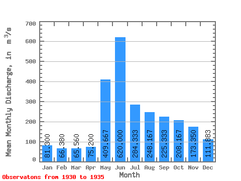
| Statistic | Jan | Feb | Mar | Apr | May | Jun | Jul | Aug | Sep | Oct | Nov | Dec | Annual |
|---|---|---|---|---|---|---|---|---|---|---|---|---|---|
| Mean | 81.30 | 66.38 | 65.56 | 75.20 | 409.67 | 620.00 | 284.33 | 248.17 | 225.33 | 208.17 | 173.35 | 111.88 | 222.91 |
| Standard Deviation | 26.12 | 16.19 | 15.22 | 17.46 | 113.56 | 255.35 | 157.06 | 161.41 | 135.74 | 110.56 | 55.99 | 20.40 | 67.35 |
| Min | 57.00 | 52.00 | 51.00 | 53.70 | 290.00 | 308.00 | 126.00 | 105.00 | 110.00 | 118.00 | 94.10 | 75.30 | 161.95 |
| Max | 124.00 | 93.80 | 88.20 | 96.10 | 560.00 | 950.00 | 552.00 | 485.00 | 462.00 | 419.00 | 257.00 | 129.00 | 322.87 |
| Coefficient of Variation | 0.32 | 0.24 | 0.23 | 0.23 | 0.28 | 0.41 | 0.55 | 0.65 | 0.60 | 0.53 | 0.32 | 0.18 | 0.30 |
 Return to R-Arctic Net Home Page