|
|
|||||||||||||||||
| Point ID: 8958 | Downloads | Plots | Site Data | Code: 71037 |
|
|
|||||||||||||||||
| Download | |
|---|---|
| Site Descriptor Information | Site Time Series Data |
| Link to all available data | |
| View: | Time Series | All |
| Units: | mm |
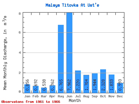
| Statistic | Jan | Feb | Mar | Apr | May | Jun | Jul | Aug | Sep | Oct | Nov | Dec | Annual |
|---|---|---|---|---|---|---|---|---|---|---|---|---|---|
| Mean | 0.86 | 0.69 | 0.54 | 0.76 | 6.76 | 7.96 | 2.22 | 1.78 | 1.94 | 2.33 | 1.83 | 0.99 | 2.38 |
| Standard Deviation | 0.33 | 0.35 | 0.20 | 0.48 | 2.67 | 2.50 | 0.90 | 0.96 | 0.56 | 0.71 | 0.52 | 0.30 | 0.38 |
| Min | 0.54 | 0.41 | 0.31 | 0.45 | 2.98 | 5.26 | 1.33 | 1.01 | 1.45 | 1.23 | 1.39 | 0.56 | 1.96 |
| Max | 1.38 | 1.25 | 0.80 | 1.58 | 8.93 | 10.50 | 3.50 | 3.33 | 2.60 | 2.91 | 2.51 | 1.39 | 2.71 |
| Coefficient of Variation | 0.39 | 0.50 | 0.38 | 0.63 | 0.39 | 0.32 | 0.41 | 0.54 | 0.29 | 0.30 | 0.28 | 0.31 | 0.16 |
 Return to R-Arctic Net Home Page