|
|
|||||||||||||||||
| Point ID: 8950 | Downloads | Plots | Site Data | Code: 71027 |
|
|
|||||||||||||||||
| Download | |
|---|---|
| Site Descriptor Information | Site Time Series Data |
| Link to all available data | |
| View: | Time Series | All |
| Units: | mm |
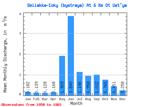
| Statistic | Jan | Feb | Mar | Apr | May | Jun | Jul | Aug | Sep | Oct | Nov | Dec | Annual |
|---|---|---|---|---|---|---|---|---|---|---|---|---|---|
| Mean | 0.18 | 0.14 | 0.13 | 0.17 | 1.91 | 3.84 | 1.15 | 0.96 | 1.01 | 0.77 | 0.45 | 0.26 | 0.92 |
| Standard Deviation | 0.04 | 0.02 | 0.03 | 0.09 | 1.15 | 1.36 | 0.66 | 0.52 | 0.52 | 0.38 | 0.17 | 0.09 | 0.13 |
| Min | 0.12 | 0.11 | 0.09 | 0.07 | 0.28 | 1.41 | 0.30 | 0.36 | 0.53 | 0.42 | 0.14 | 0.13 | 0.68 |
| Max | 0.25 | 0.17 | 0.19 | 0.40 | 3.37 | 5.15 | 2.35 | 1.71 | 2.40 | 1.65 | 0.71 | 0.44 | 1.13 |
| Coefficient of Variation | 0.24 | 0.14 | 0.26 | 0.55 | 0.60 | 0.35 | 0.58 | 0.54 | 0.51 | 0.49 | 0.37 | 0.34 | 0.14 |
 Return to R-Arctic Net Home Page