|
|
|||||||||||||||||
| Point ID: 8934 | Downloads | Plots | Site Data | Code: 70604 |
|
|
|||||||||||||||||
| Download | |
|---|---|
| Site Descriptor Information | Site Time Series Data |
| Link to all available data | |
| View: | Time Series | All |
| Units: | mm |
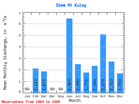
| Statistic | Jan | Feb | Mar | Apr | May | Jun | Jul | Aug | Sep | Oct | Nov | Dec | Annual |
|---|---|---|---|---|---|---|---|---|---|---|---|---|---|
| Mean | 2.11 | 1.87 | 6.46 | 2.49 | 1.77 | 2.34 | 5.07 | 2.71 | 1.70 | ||||
| Standard Deviation | |||||||||||||
| Min | 2.11 | 1.87 | 6.46 | 2.49 | 1.77 | 2.34 | 5.07 | 2.71 | 1.70 | ||||
| Max | 2.11 | 1.87 | 6.46 | 2.49 | 1.77 | 2.34 | 5.07 | 2.71 | 1.70 | ||||
| Coefficient of Variation |
 Return to R-Arctic Net Home Page