|
|
|||||||||||||||||
| Point ID: 893 | Downloads | Plots | Site Data | Code: 07FC003 |
|
|
|||||||||||||||||
| Download | |
|---|---|
| Site Descriptor Information | Site Time Series Data |
| Link to all available data | |
| View: | Time Series | All |
| Units: | mm |
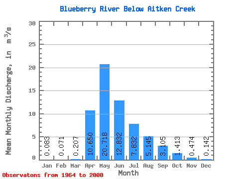
| Statistic | Jan | Feb | Mar | Apr | May | Jun | Jul | Aug | Sep | Oct | Nov | Dec | Annual |
|---|---|---|---|---|---|---|---|---|---|---|---|---|---|
| Mean | 0.08 | 0.07 | 0.21 | 10.65 | 20.72 | 12.83 | 7.83 | 5.14 | 3.10 | 1.41 | 0.47 | 0.14 | 5.24 |
| Standard Deviation | 0.05 | 0.04 | 0.33 | 10.66 | 13.71 | 12.24 | 7.66 | 12.06 | 5.32 | 2.89 | 0.98 | 0.09 | 2.47 |
| Min | 0.00 | 0.00 | 0.01 | 0.20 | 2.07 | 1.46 | 0.02 | 0.03 | 0.03 | 0.10 | 0.04 | 0.02 | 1.86 |
| Max | 0.20 | 0.19 | 1.97 | 42.80 | 54.70 | 50.30 | 26.30 | 58.20 | 24.70 | 17.20 | 6.02 | 0.34 | 9.57 |
| Coefficient of Variation | 0.62 | 0.63 | 1.60 | 1.00 | 0.66 | 0.95 | 0.98 | 2.34 | 1.71 | 2.04 | 2.06 | 0.60 | 0.47 |
 Return to R-Arctic Net Home Page