|
|
|||||||||||||||||
| Point ID: 8923 | Downloads | Plots | Site Data | Code: 70587 |
|
|
|||||||||||||||||
| Download | |
|---|---|
| Site Descriptor Information | Site Time Series Data |
| Link to all available data | |
| View: | Time Series | All |
| Units: | mm |
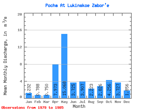
| Statistic | Jan | Feb | Mar | Apr | May | Jun | Jul | Aug | Sep | Oct | Nov | Dec | Annual |
|---|---|---|---|---|---|---|---|---|---|---|---|---|---|
| Mean | 1.23 | 0.79 | 0.75 | 7.97 | 15.07 | 3.73 | 3.91 | 2.22 | 2.83 | 4.26 | 3.73 | 1.86 | 4.03 |
| Standard Deviation | 0.47 | 0.26 | 0.19 | 8.05 | 8.44 | 1.03 | 2.60 | 1.87 | 1.66 | 1.89 | 1.61 | 0.76 | 0.51 |
| Min | 0.66 | 0.45 | 0.53 | 1.12 | 6.01 | 2.70 | 1.10 | 0.74 | 0.87 | 1.22 | 2.06 | 1.04 | 3.53 |
| Max | 1.71 | 1.17 | 1.09 | 23.00 | 30.40 | 4.88 | 8.23 | 5.07 | 5.43 | 6.58 | 6.25 | 3.32 | 4.67 |
| Coefficient of Variation | 0.38 | 0.33 | 0.26 | 1.01 | 0.56 | 0.28 | 0.67 | 0.84 | 0.59 | 0.44 | 0.43 | 0.41 | 0.13 |
 Return to R-Arctic Net Home Page