|
|
|||||||||||||||||
| Point ID: 8921 | Downloads | Plots | Site Data | Code: 70585 |
|
|
|||||||||||||||||
| Download | |
|---|---|
| Site Descriptor Information | Site Time Series Data |
| Link to all available data | |
| View: | Time Series | All |
| Units: | mm |
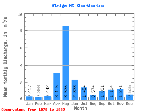
| Statistic | Jan | Feb | Mar | Apr | May | Jun | Jul | Aug | Sep | Oct | Nov | Dec | Annual |
|---|---|---|---|---|---|---|---|---|---|---|---|---|---|
| Mean | 0.42 | 0.36 | 0.44 | 3.12 | 8.54 | 2.34 | 1.45 | 0.57 | 1.03 | 1.19 | 1.27 | 0.64 | 1.82 |
| Standard Deviation | 0.16 | 0.15 | 0.33 | 2.43 | 5.12 | 2.04 | 1.16 | 0.30 | 0.87 | 0.70 | 0.84 | 0.26 | 0.36 |
| Min | 0.27 | 0.21 | 0.29 | 0.62 | 1.69 | 0.66 | 0.38 | 0.27 | 0.37 | 0.55 | 0.63 | 0.41 | 1.25 |
| Max | 0.62 | 0.55 | 1.12 | 7.31 | 16.10 | 5.82 | 3.14 | 1.19 | 2.84 | 2.55 | 2.94 | 1.19 | 2.22 |
| Coefficient of Variation | 0.38 | 0.42 | 0.75 | 0.78 | 0.60 | 0.87 | 0.80 | 0.53 | 0.84 | 0.59 | 0.66 | 0.41 | 0.20 |
 Return to R-Arctic Net Home Page