|
|
|||||||||||||||||
| Point ID: 8911 | Downloads | Plots | Site Data | Code: 70574 |
|
|
|||||||||||||||||
| Download | |
|---|---|
| Site Descriptor Information | Site Time Series Data |
| Link to all available data | |
| View: | Time Series | All |
| Units: | mm |
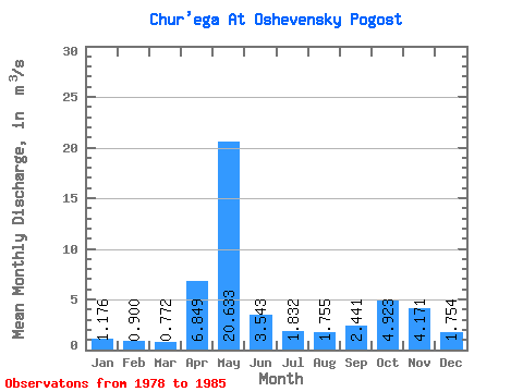
| Statistic | Jan | Feb | Mar | Apr | May | Jun | Jul | Aug | Sep | Oct | Nov | Dec | Annual |
|---|---|---|---|---|---|---|---|---|---|---|---|---|---|
| Mean | 1.18 | 0.90 | 0.77 | 6.85 | 20.63 | 3.54 | 1.83 | 1.75 | 2.44 | 4.92 | 4.17 | 1.75 | 4.20 |
| Standard Deviation | 0.57 | 0.34 | 0.32 | 7.97 | 6.54 | 2.77 | 1.33 | 1.73 | 2.99 | 3.45 | 2.05 | 0.82 | 1.12 |
| Min | 0.70 | 0.62 | 0.46 | 0.68 | 7.83 | 1.20 | 0.72 | 0.58 | 0.88 | 0.80 | 0.84 | 0.62 | 2.56 |
| Max | 2.31 | 1.62 | 1.37 | 22.60 | 28.20 | 9.29 | 4.50 | 5.52 | 9.08 | 10.20 | 6.14 | 3.10 | 6.09 |
| Coefficient of Variation | 0.49 | 0.38 | 0.42 | 1.16 | 0.32 | 0.78 | 0.73 | 0.98 | 1.22 | 0.70 | 0.49 | 0.47 | 0.27 |
 Return to R-Arctic Net Home Page