|
|
|||||||||||||||||
| Point ID: 8908 | Downloads | Plots | Site Data | Code: 70569 |
|
|
|||||||||||||||||
| Download | |
|---|---|
| Site Descriptor Information | Site Time Series Data |
| Link to all available data | |
| View: | Time Series | All |
| Units: | mm |
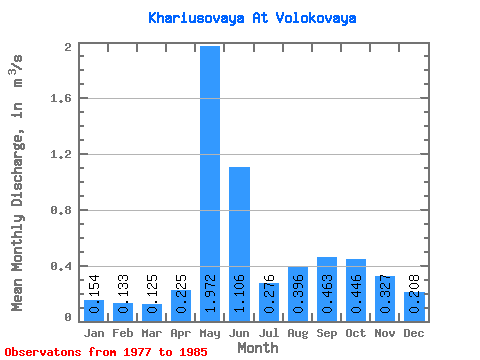
| Statistic | Jan | Feb | Mar | Apr | May | Jun | Jul | Aug | Sep | Oct | Nov | Dec | Annual |
|---|---|---|---|---|---|---|---|---|---|---|---|---|---|
| Mean | 0.15 | 0.13 | 0.12 | 0.23 | 1.97 | 1.11 | 0.28 | 0.40 | 0.46 | 0.45 | 0.33 | 0.21 | 0.53 |
| Standard Deviation | 0.03 | 0.03 | 0.03 | 0.19 | 0.73 | 0.98 | 0.07 | 0.29 | 0.25 | 0.17 | 0.13 | 0.07 | 0.13 |
| Min | 0.12 | 0.08 | 0.08 | 0.06 | 0.96 | 0.31 | 0.20 | 0.19 | 0.17 | 0.25 | 0.14 | 0.14 | 0.40 |
| Max | 0.20 | 0.17 | 0.16 | 0.64 | 3.01 | 3.17 | 0.37 | 1.05 | 0.85 | 0.70 | 0.50 | 0.34 | 0.71 |
| Coefficient of Variation | 0.18 | 0.24 | 0.23 | 0.82 | 0.37 | 0.89 | 0.23 | 0.72 | 0.53 | 0.39 | 0.39 | 0.32 | 0.25 |
 Return to R-Arctic Net Home Page