|
|
|||||||||||||||||
| Point ID: 8881 | Downloads | Plots | Site Data | Code: 70483 |
|
|
|||||||||||||||||
| Download | |
|---|---|
| Site Descriptor Information | Site Time Series Data |
| Link to all available data | |
| View: | Time Series | All |
| Units: | mm |
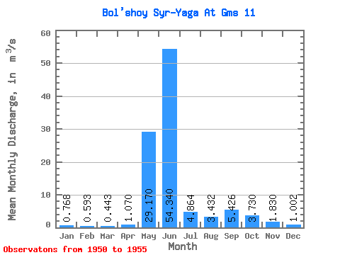
| Statistic | Jan | Feb | Mar | Apr | May | Jun | Jul | Aug | Sep | Oct | Nov | Dec | Annual |
|---|---|---|---|---|---|---|---|---|---|---|---|---|---|
| Mean | 0.77 | 0.59 | 0.44 | 1.07 | 29.17 | 54.34 | 4.86 | 3.43 | 5.43 | 3.73 | 1.83 | 1.00 | 10.81 |
| Standard Deviation | 0.58 | 0.54 | 0.59 | 0.55 | 25.23 | 39.86 | 3.24 | 2.17 | 2.73 | 3.94 | 1.63 | 0.61 | 3.14 |
| Min | 0.28 | 0.19 | 0.10 | 0.60 | 2.95 | 10.10 | 2.75 | 1.80 | 2.55 | 1.54 | 0.52 | 0.46 | 8.59 |
| Max | 1.57 | 1.37 | 1.12 | 1.67 | 65.00 | 108.00 | 10.60 | 7.14 | 9.24 | 10.70 | 4.57 | 1.81 | 13.04 |
| Coefficient of Variation | 0.75 | 0.91 | 1.32 | 0.51 | 0.86 | 0.73 | 0.67 | 0.63 | 0.50 | 1.05 | 0.89 | 0.61 | 0.29 |
 Return to R-Arctic Net Home Page