|
|
|||||||||||||||||
| Point ID: 8878 | Downloads | Plots | Site Data | Code: 70478 |
|
|
|||||||||||||||||
| Download | |
|---|---|
| Site Descriptor Information | Site Time Series Data |
| Link to all available data | |
| View: | Time Series | All |
| Units: | mm |
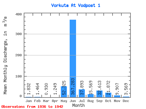
| Statistic | Jan | Feb | Mar | Apr | May | Jun | Jul | Aug | Sep | Oct | Nov | Dec | Annual |
|---|---|---|---|---|---|---|---|---|---|---|---|---|---|
| Mean | 1.83 | 1.46 | 0.93 | 1.25 | 52.33 | 367.28 | 37.89 | 15.57 | 32.61 | 21.87 | 9.91 | 3.57 | 44.71 |
| Standard Deviation | 0.93 | 0.71 | 0.55 | 0.88 | 98.26 | 167.43 | 25.02 | 6.43 | 17.52 | 15.68 | 7.25 | 1.06 | 10.22 |
| Min | 0.65 | 0.56 | 0.35 | 0.37 | 1.35 | 37.70 | 9.75 | 9.58 | 6.79 | 5.54 | 4.54 | 2.25 | 30.18 |
| Max | 2.89 | 2.36 | 1.90 | 2.48 | 251.00 | 479.00 | 72.80 | 28.10 | 62.50 | 45.00 | 24.10 | 4.78 | 56.75 |
| Coefficient of Variation | 0.51 | 0.48 | 0.59 | 0.70 | 1.88 | 0.46 | 0.66 | 0.41 | 0.54 | 0.72 | 0.73 | 0.30 | 0.23 |
 Return to R-Arctic Net Home Page