|
|
|||||||||||||||||
| Point ID: 8872 | Downloads | Plots | Site Data | Code: 70450 |
|
|
|||||||||||||||||
| Download | |
|---|---|
| Site Descriptor Information | Site Time Series Data |
| Link to all available data | |
| View: | Time Series | All |
| Units: | mm |
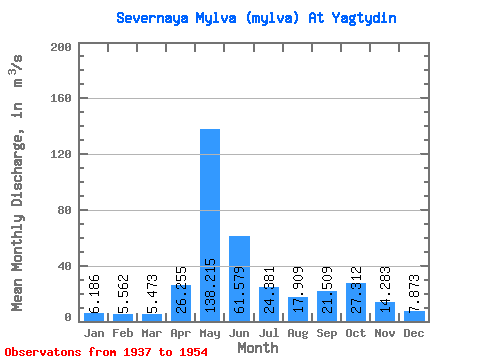
| Statistic | Jan | Feb | Mar | Apr | May | Jun | Jul | Aug | Sep | Oct | Nov | Dec | Annual |
|---|---|---|---|---|---|---|---|---|---|---|---|---|---|
| Mean | 6.19 | 5.56 | 5.47 | 26.25 | 138.22 | 61.58 | 24.38 | 17.91 | 21.51 | 27.31 | 14.28 | 7.87 | 29.50 |
| Standard Deviation | 1.35 | 1.04 | 0.71 | 32.23 | 43.19 | 29.50 | 17.73 | 12.27 | 13.17 | 15.51 | 6.42 | 1.98 | 5.60 |
| Min | 4.10 | 3.66 | 4.46 | 4.87 | 68.60 | 11.40 | 8.84 | 6.91 | 7.41 | 6.39 | 6.42 | 5.16 | 15.36 |
| Max | 8.05 | 7.07 | 6.53 | 103.00 | 199.00 | 124.00 | 71.00 | 42.40 | 49.30 | 57.60 | 27.90 | 12.10 | 38.76 |
| Coefficient of Variation | 0.22 | 0.19 | 0.13 | 1.23 | 0.31 | 0.48 | 0.73 | 0.69 | 0.61 | 0.57 | 0.45 | 0.25 | 0.19 |
 Return to R-Arctic Net Home Page