|
|
|||||||||||||||||
| Point ID: 887 | Downloads | Plots | Site Data | Code: 07FB008 |
|
|
|||||||||||||||||
| Download | |
|---|---|
| Site Descriptor Information | Site Time Series Data |
| Link to all available data | |
| View: | Time Series | All |
| Units: | mm |
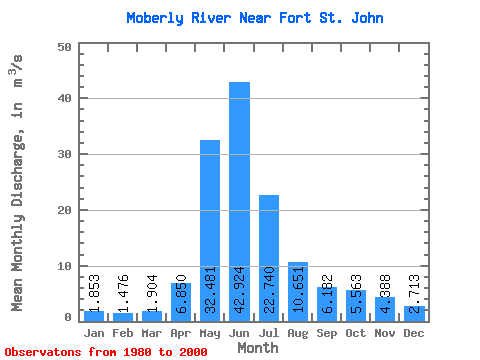
| Statistic | Jan | Feb | Mar | Apr | May | Jun | Jul | Aug | Sep | Oct | Nov | Dec | Annual |
|---|---|---|---|---|---|---|---|---|---|---|---|---|---|
| Mean | 1.85 | 1.48 | 1.90 | 6.85 | 32.48 | 42.92 | 22.74 | 10.65 | 6.18 | 5.56 | 4.39 | 2.71 | 11.64 |
| Standard Deviation | 0.91 | 0.57 | 1.54 | 4.78 | 15.10 | 14.07 | 12.12 | 11.82 | 5.17 | 3.83 | 2.86 | 1.43 | 2.79 |
| Min | 0.48 | 0.47 | 0.50 | 1.54 | 4.51 | 18.70 | 7.66 | 2.52 | 0.61 | 0.54 | 0.41 | 0.41 | 8.04 |
| Max | 3.91 | 2.71 | 8.08 | 17.10 | 68.80 | 83.20 | 56.70 | 55.30 | 20.10 | 13.50 | 11.20 | 5.57 | 18.43 |
| Coefficient of Variation | 0.49 | 0.39 | 0.81 | 0.70 | 0.47 | 0.33 | 0.53 | 1.11 | 0.84 | 0.69 | 0.65 | 0.53 | 0.24 |
 Return to R-Arctic Net Home Page