|
|
|||||||||||||||||
| Point ID: 8869 | Downloads | Plots | Site Data | Code: 70441 |
|
|
|||||||||||||||||
| Download | |
|---|---|
| Site Descriptor Information | Site Time Series Data |
| Link to all available data | |
| View: | Time Series | All |
| Units: | mm |
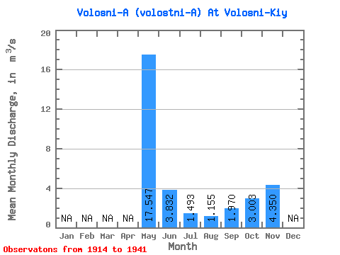
| Statistic | Jan | Feb | Mar | Apr | May | Jun | Jul | Aug | Sep | Oct | Nov | Dec | Annual |
|---|---|---|---|---|---|---|---|---|---|---|---|---|---|
| Mean | 17.55 | 3.83 | 1.49 | 1.16 | 1.97 | 3.00 | 4.35 | ||||||
| Standard Deviation | 6.76 | 2.79 | 1.40 | 1.22 | 1.94 | 1.96 | |||||||
| Min | 7.17 | 0.74 | 0.07 | 0.04 | 0.03 | 0.62 | 4.35 | ||||||
| Max | 31.10 | 10.00 | 5.48 | 3.74 | 5.90 | 7.77 | 4.35 | ||||||
| Coefficient of Variation | 0.39 | 0.73 | 0.94 | 1.06 | 0.99 | 0.65 |
 Return to R-Arctic Net Home Page