|
|
|||||||||||||||||
| Point ID: 8860 | Downloads | Plots | Site Data | Code: 70347 |
|
|
|||||||||||||||||
| Download | |
|---|---|
| Site Descriptor Information | Site Time Series Data |
| Link to all available data | |
| View: | Time Series | All |
| Units: | mm |
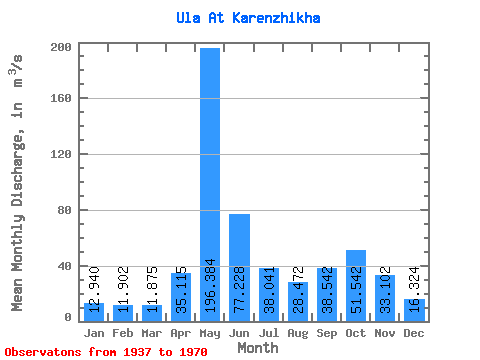
| Statistic | Jan | Feb | Mar | Apr | May | Jun | Jul | Aug | Sep | Oct | Nov | Dec | Annual |
|---|---|---|---|---|---|---|---|---|---|---|---|---|---|
| Mean | 12.94 | 11.90 | 11.88 | 35.12 | 196.38 | 77.23 | 38.04 | 28.47 | 38.54 | 51.54 | 33.10 | 16.32 | 46.21 |
| Standard Deviation | 2.64 | 1.98 | 1.75 | 37.94 | 80.27 | 42.26 | 18.70 | 20.99 | 23.02 | 28.39 | 17.47 | 4.84 | 8.83 |
| Min | 8.69 | 9.08 | 9.27 | 10.30 | 19.50 | 24.70 | 18.10 | 11.30 | 13.80 | 13.90 | 9.97 | 10.10 | 27.24 |
| Max | 21.90 | 17.80 | 15.90 | 159.00 | 342.00 | 211.00 | 96.10 | 113.00 | 92.70 | 125.00 | 76.30 | 31.20 | 64.54 |
| Coefficient of Variation | 0.20 | 0.17 | 0.15 | 1.08 | 0.41 | 0.55 | 0.49 | 0.74 | 0.60 | 0.55 | 0.53 | 0.30 | 0.19 |
 Return to R-Arctic Net Home Page