|
|
|||||||||||||||||
| Point ID: 8854 | Downloads | Plots | Site Data | Code: 70296 |
|
|
|||||||||||||||||
| Download | |
|---|---|
| Site Descriptor Information | Site Time Series Data |
| Link to all available data | |
| View: | Time Series | All |
| Units: | mm |
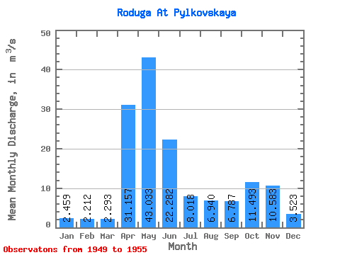
| Statistic | Jan | Feb | Mar | Apr | May | Jun | Jul | Aug | Sep | Oct | Nov | Dec | Annual |
|---|---|---|---|---|---|---|---|---|---|---|---|---|---|
| Mean | 2.46 | 2.21 | 2.29 | 31.16 | 43.03 | 22.28 | 8.02 | 6.94 | 6.79 | 11.49 | 10.58 | 3.52 | 12.79 |
| Standard Deviation | 0.59 | 0.44 | 0.35 | 22.86 | 28.81 | 13.21 | 4.16 | 5.05 | 5.10 | 7.09 | 12.44 | 1.30 | 3.47 |
| Min | 1.42 | 1.60 | 1.95 | 7.64 | 15.60 | 8.89 | 3.34 | 2.69 | 2.72 | 2.69 | 2.32 | 1.92 | 6.81 |
| Max | 2.95 | 2.69 | 2.88 | 64.10 | 95.60 | 40.30 | 15.50 | 13.70 | 16.90 | 21.30 | 37.60 | 4.90 | 16.94 |
| Coefficient of Variation | 0.24 | 0.20 | 0.15 | 0.73 | 0.67 | 0.59 | 0.52 | 0.73 | 0.75 | 0.62 | 1.18 | 0.37 | 0.27 |
 Return to R-Arctic Net Home Page