|
|
|||||||||||||||||
| Point ID: 884 | Downloads | Plots | Site Data | Code: 07FB005 |
|
|
|||||||||||||||||
| Download | |
|---|---|
| Site Descriptor Information | Site Time Series Data |
| Link to all available data | |
| View: | Time Series | All |
| Units: | mm |
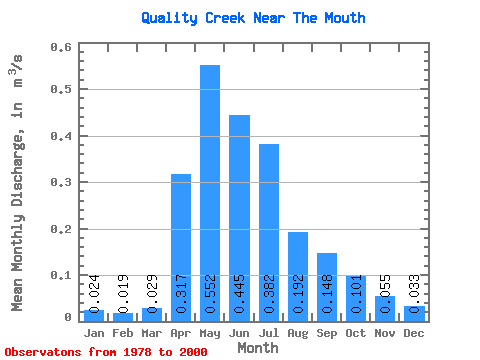
| Statistic | Jan | Feb | Mar | Apr | May | Jun | Jul | Aug | Sep | Oct | Nov | Dec | Annual |
|---|---|---|---|---|---|---|---|---|---|---|---|---|---|
| Mean | 0.02 | 0.02 | 0.03 | 0.32 | 0.55 | 0.45 | 0.38 | 0.19 | 0.15 | 0.10 | 0.06 | 0.03 | 0.20 |
| Standard Deviation | 0.02 | 0.01 | 0.03 | 0.23 | 0.42 | 0.38 | 0.43 | 0.24 | 0.16 | 0.10 | 0.04 | 0.02 | 0.10 |
| Min | 0.00 | 0.00 | 0.00 | 0.02 | 0.04 | 0.04 | 0.01 | 0.01 | 0.00 | 0.01 | 0.00 | 0.00 | 0.06 |
| Max | 0.05 | 0.06 | 0.11 | 0.77 | 1.43 | 1.47 | 1.67 | 0.91 | 0.67 | 0.34 | 0.17 | 0.08 | 0.42 |
| Coefficient of Variation | 0.73 | 0.82 | 0.96 | 0.72 | 0.75 | 0.85 | 1.12 | 1.24 | 1.10 | 0.95 | 0.82 | 0.68 | 0.49 |
 Return to R-Arctic Net Home Page