|
|
|||||||||||||||||
| Point ID: 8830 | Downloads | Plots | Site Data | Code: 70035 |
|
|
|||||||||||||||||
| Download | |
|---|---|
| Site Descriptor Information | Site Time Series Data |
| Link to all available data | |
| View: | Time Series | All |
| Units: | mm |
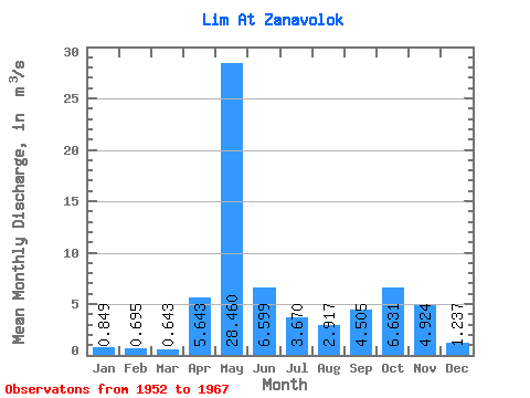
| Statistic | Jan | Feb | Mar | Apr | May | Jun | Jul | Aug | Sep | Oct | Nov | Dec | Annual |
|---|---|---|---|---|---|---|---|---|---|---|---|---|---|
| Mean | 0.85 | 0.69 | 0.64 | 5.64 | 28.46 | 6.60 | 3.67 | 2.92 | 4.50 | 6.63 | 4.92 | 1.24 | 5.58 |
| Standard Deviation | 0.24 | 0.16 | 0.16 | 6.35 | 10.50 | 2.91 | 2.36 | 3.81 | 3.81 | 4.01 | 4.44 | 0.43 | 1.31 |
| Min | 0.42 | 0.40 | 0.37 | 0.63 | 11.40 | 2.26 | 0.96 | 0.44 | 0.86 | 2.32 | 0.68 | 0.45 | 3.35 |
| Max | 1.35 | 1.02 | 0.92 | 21.90 | 46.20 | 12.50 | 9.96 | 12.10 | 14.80 | 18.70 | 19.10 | 2.08 | 7.96 |
| Coefficient of Variation | 0.28 | 0.23 | 0.25 | 1.12 | 0.37 | 0.44 | 0.64 | 1.31 | 0.85 | 0.60 | 0.90 | 0.35 | 0.23 |
 Return to R-Arctic Net Home Page