|
|
|||||||||||||||||
| Point ID: 8821 | Downloads | Plots | Site Data | Code: 12394 |
|
|
|||||||||||||||||
| Download | |
|---|---|
| Site Descriptor Information | Site Time Series Data |
| Link to all available data | |
| View: | Time Series | All |
| Units: | mm |
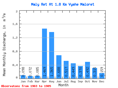
| Statistic | Jan | Feb | Mar | Apr | May | Jun | Jul | Aug | Sep | Oct | Nov | Dec | Annual |
|---|---|---|---|---|---|---|---|---|---|---|---|---|---|
| Mean | 0.10 | 0.07 | 0.09 | 1.47 | 1.36 | 0.69 | 0.52 | 0.45 | 0.37 | 0.49 | 0.32 | 0.16 | 0.51 |
| Standard Deviation | 0.06 | 0.04 | 0.05 | 1.03 | 0.97 | 0.38 | 0.53 | 0.52 | 0.40 | 0.55 | 0.32 | 0.11 | 0.24 |
| Min | 0.03 | 0.02 | 0.02 | 0.16 | 0.13 | 0.13 | 0.04 | 0.06 | 0.05 | 0.05 | 0.04 | 0.03 | 0.10 |
| Max | 0.23 | 0.16 | 0.23 | 3.88 | 4.12 | 1.30 | 2.02 | 2.42 | 1.54 | 2.24 | 1.28 | 0.42 | 0.93 |
| Coefficient of Variation | 0.56 | 0.53 | 0.63 | 0.70 | 0.71 | 0.55 | 1.02 | 1.16 | 1.09 | 1.11 | 1.01 | 0.66 | 0.47 |
 Return to R-Arctic Net Home Page