|
|
|||||||||||||||||
| Point ID: 8818 | Downloads | Plots | Site Data | Code: 12388 |
|
|
|||||||||||||||||
| Download | |
|---|---|
| Site Descriptor Information | Site Time Series Data |
| Link to all available data | |
| View: | Time Series | All |
| Units: | mm |
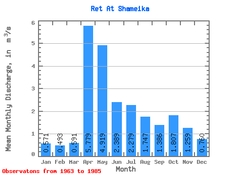
| Statistic | Jan | Feb | Mar | Apr | May | Jun | Jul | Aug | Sep | Oct | Nov | Dec | Annual |
|---|---|---|---|---|---|---|---|---|---|---|---|---|---|
| Mean | 0.57 | 0.49 | 0.59 | 5.78 | 4.92 | 2.39 | 2.28 | 1.75 | 1.39 | 1.81 | 1.26 | 0.76 | 2.02 |
| Standard Deviation | 0.23 | 0.19 | 0.30 | 3.97 | 3.73 | 1.34 | 2.76 | 2.23 | 1.46 | 1.89 | 1.20 | 0.38 | 0.94 |
| Min | 0.19 | 0.19 | 0.15 | 0.98 | 0.41 | 0.40 | 0.21 | 0.33 | 0.28 | 0.34 | 0.31 | 0.27 | 0.52 |
| Max | 1.09 | 0.90 | 1.57 | 14.70 | 17.00 | 4.57 | 12.00 | 10.70 | 5.37 | 8.60 | 5.94 | 1.76 | 3.60 |
| Coefficient of Variation | 0.40 | 0.39 | 0.50 | 0.69 | 0.76 | 0.56 | 1.21 | 1.28 | 1.05 | 1.05 | 0.95 | 0.50 | 0.47 |
 Return to R-Arctic Net Home Page