|
|
|||||||||||||||||
| Point ID: 8815 | Downloads | Plots | Site Data | Code: 12379 |
|
|
|||||||||||||||||
| Download | |
|---|---|
| Site Descriptor Information | Site Time Series Data |
| Link to all available data | |
| View: | Time Series | All |
| Units: | mm |
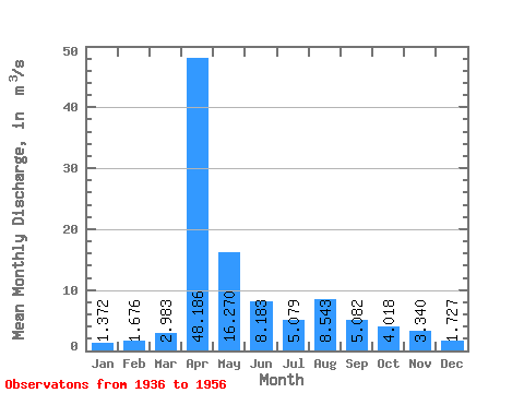
| Statistic | Jan | Feb | Mar | Apr | May | Jun | Jul | Aug | Sep | Oct | Nov | Dec | Annual |
|---|---|---|---|---|---|---|---|---|---|---|---|---|---|
| Mean | 1.37 | 1.68 | 2.98 | 48.19 | 16.27 | 8.18 | 5.08 | 8.54 | 5.08 | 4.02 | 3.34 | 1.73 | 8.87 |
| Standard Deviation | 0.54 | 0.79 | 1.72 | 26.05 | 7.41 | 4.77 | 2.99 | 12.24 | 6.74 | 2.19 | 1.32 | 1.28 | 2.04 |
| Min | 0.41 | 0.64 | 0.07 | 25.30 | 6.19 | 3.28 | 2.12 | 1.28 | 1.48 | 1.75 | 1.65 | 0.40 | 6.46 |
| Max | 2.09 | 2.80 | 5.03 | 101.00 | 28.10 | 17.80 | 10.50 | 34.50 | 20.20 | 8.64 | 5.40 | 3.68 | 11.96 |
| Coefficient of Variation | 0.39 | 0.47 | 0.58 | 0.54 | 0.46 | 0.58 | 0.59 | 1.43 | 1.33 | 0.55 | 0.39 | 0.74 | 0.23 |
 Return to R-Arctic Net Home Page