|
|
|||||||||||||||||
| Point ID: 8795 | Downloads | Plots | Site Data | Code: 12256 |
|
|
|||||||||||||||||
| Download | |
|---|---|
| Site Descriptor Information | Site Time Series Data |
| Link to all available data | |
| View: | Time Series | All |
| Units: | mm |
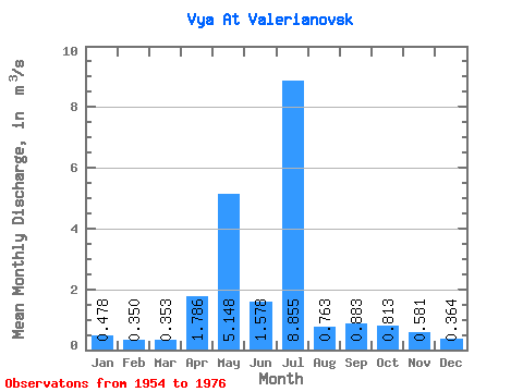
| Statistic | Jan | Feb | Mar | Apr | May | Jun | Jul | Aug | Sep | Oct | Nov | Dec | Annual |
|---|---|---|---|---|---|---|---|---|---|---|---|---|---|
| Mean | 0.48 | 0.35 | 0.35 | 1.79 | 5.15 | 1.58 | 8.86 | 0.76 | 0.88 | 0.81 | 0.58 | 0.36 | 1.29 |
| Standard Deviation | 0.32 | 0.15 | 0.25 | 0.90 | 3.56 | 0.65 | 22.29 | 0.33 | 0.83 | 0.43 | 0.23 | 0.12 | 0.26 |
| Min | 0.27 | 0.21 | 0.17 | 0.54 | 1.11 | 0.67 | 0.30 | 0.33 | 0.29 | 0.44 | 0.28 | 0.19 | 0.95 |
| Max | 1.13 | 0.62 | 0.85 | 3.26 | 11.00 | 2.76 | 64.00 | 1.09 | 2.78 | 1.58 | 0.94 | 0.52 | 1.67 |
| Coefficient of Variation | 0.68 | 0.43 | 0.72 | 0.50 | 0.69 | 0.41 | 2.52 | 0.43 | 0.94 | 0.53 | 0.39 | 0.33 | 0.20 |
 Return to R-Arctic Net Home Page