|
|
|||||||||||||||||
| Point ID: 8778 | Downloads | Plots | Site Data | Code: 12134 |
|
|
|||||||||||||||||
| Download | |
|---|---|
| Site Descriptor Information | Site Time Series Data |
| Link to all available data | |
| View: | Time Series | All |
| Units: | mm |
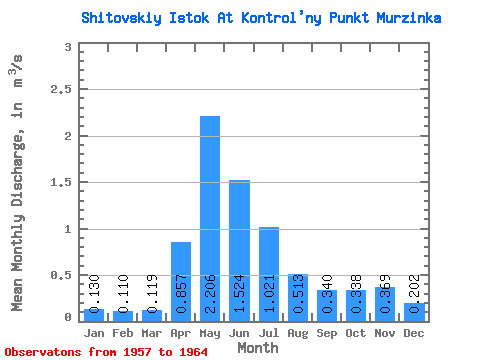
| Statistic | Jan | Feb | Mar | Apr | May | Jun | Jul | Aug | Sep | Oct | Nov | Dec | Annual |
|---|---|---|---|---|---|---|---|---|---|---|---|---|---|
| Mean | 0.13 | 0.11 | 0.12 | 0.86 | 2.21 | 1.52 | 1.02 | 0.51 | 0.34 | 0.34 | 0.37 | 0.20 | 0.64 |
| Standard Deviation | 0.07 | 0.05 | 0.06 | 0.42 | 1.09 | 0.61 | 0.75 | 0.37 | 0.13 | 0.12 | 0.18 | 0.10 | 0.20 |
| Min | 0.07 | 0.04 | 0.02 | 0.29 | 0.50 | 0.29 | 0.31 | 0.15 | 0.12 | 0.13 | 0.13 | 0.08 | 0.28 |
| Max | 0.26 | 0.20 | 0.19 | 1.48 | 4.12 | 2.48 | 2.29 | 1.07 | 0.53 | 0.46 | 0.65 | 0.32 | 0.91 |
| Coefficient of Variation | 0.50 | 0.46 | 0.50 | 0.49 | 0.49 | 0.40 | 0.73 | 0.72 | 0.39 | 0.36 | 0.49 | 0.47 | 0.31 |
 Return to R-Arctic Net Home Page