|
|
|||||||||||||||||
| Point ID: 877 | Downloads | Plots | Site Data | Other Close Sites | Code: 07FA004 |
|
|
|||||||||||||||||
| Download | |
|---|---|
| Site Descriptor Information | Site Time Series Data |
| Link to all available data | |
| View: | Time Series | All |
| Units: | mm |
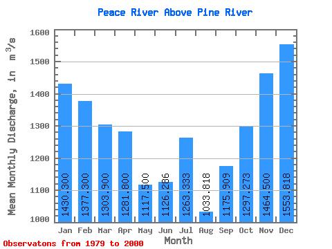
| Statistic | Jan | Feb | Mar | Apr | May | Jun | Jul | Aug | Sep | Oct | Nov | Dec | Annual |
|---|---|---|---|---|---|---|---|---|---|---|---|---|---|
| Mean | 1430.30 | 1377.30 | 1303.90 | 1281.80 | 1117.50 | 1126.29 | 1263.33 | 1033.82 | 1175.91 | 1297.27 | 1464.50 | 1553.82 | 1293.70 |
| Standard Deviation | 316.27 | 377.81 | 386.78 | 382.18 | 359.68 | 508.15 | 1054.99 | 496.24 | 281.74 | 206.52 | 278.88 | 283.05 | 233.15 |
| Min | 689.00 | 560.00 | 490.00 | 617.00 | 424.00 | 590.00 | 449.00 | 441.00 | 645.00 | 950.00 | 821.00 | 894.00 | 898.42 |
| Max | 1950.00 | 1860.00 | 1840.00 | 1940.00 | 1820.00 | 2770.00 | 5400.00 | 2820.00 | 1720.00 | 1660.00 | 1820.00 | 1930.00 | 1949.17 |
| Coefficient of Variation | 0.22 | 0.27 | 0.30 | 0.30 | 0.32 | 0.45 | 0.83 | 0.48 | 0.24 | 0.16 | 0.19 | 0.18 | 0.18 |
| Other Close Sites | ||||||
|---|---|---|---|---|---|---|
| PointID | Latitude | Longitude | Drainage Area | Source | Name | |
| 891 | "BEATTON RIVER NEAR FORT ST. JOHN" | 56.27 | 1885716 | Hydat | ||
| 898 | "PEACE RIVER NEAR TAYLOR" | 56.13 | 1893314 | Hydat | ||
 Return to R-Arctic Net Home Page