|
|
|||||||||||||||||
| Point ID: 8767 | Downloads | Plots | Site Data | Code: 12064 |
|
|
|||||||||||||||||
| Download | |
|---|---|
| Site Descriptor Information | Site Time Series Data |
| Link to all available data | |
| View: | Time Series | All |
| Units: | mm |
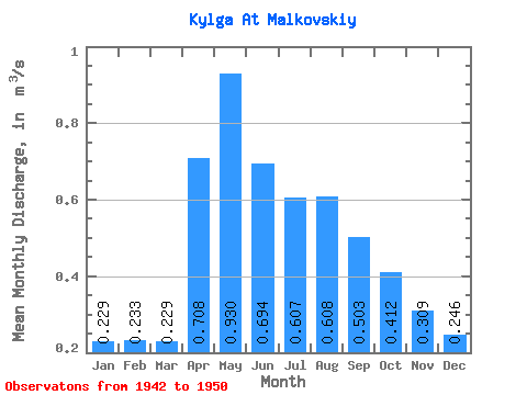
| Statistic | Jan | Feb | Mar | Apr | May | Jun | Jul | Aug | Sep | Oct | Nov | Dec | Annual |
|---|---|---|---|---|---|---|---|---|---|---|---|---|---|
| Mean | 0.23 | 0.23 | 0.23 | 0.71 | 0.93 | 0.69 | 0.61 | 0.61 | 0.50 | 0.41 | 0.31 | 0.25 | 0.56 |
| Standard Deviation | 0.35 | 0.34 | 0.35 | 0.51 | 0.68 | 0.46 | 0.42 | 0.59 | 0.49 | 0.41 | 0.32 | 0.27 | 0.31 |
| Min | 0.00 | 0.00 | 0.00 | 0.00 | 0.11 | 0.01 | 0.01 | 0.00 | 0.00 | 0.00 | 0.00 | 0.00 | 0.27 |
| Max | 0.96 | 0.95 | 1.00 | 1.48 | 2.20 | 1.35 | 1.36 | 1.46 | 1.09 | 0.82 | 0.68 | 0.62 | 1.09 |
| Coefficient of Variation | 1.52 | 1.46 | 1.54 | 0.71 | 0.73 | 0.67 | 0.70 | 0.97 | 0.97 | 0.99 | 1.03 | 1.10 | 0.55 |
 Return to R-Arctic Net Home Page