|
|
|||||||||||||||||
| Point ID: 8765 | Downloads | Plots | Site Data | Code: 12060 |
|
|
|||||||||||||||||
| Download | |
|---|---|
| Site Descriptor Information | Site Time Series Data |
| Link to all available data | |
| View: | Time Series | All |
| Units: | mm |
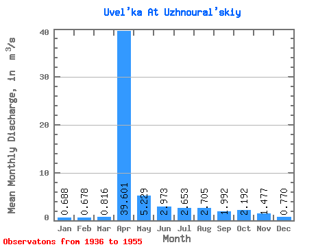
| Statistic | Jan | Feb | Mar | Apr | May | Jun | Jul | Aug | Sep | Oct | Nov | Dec | Annual |
|---|---|---|---|---|---|---|---|---|---|---|---|---|---|
| Mean | 0.69 | 0.68 | 0.82 | 39.60 | 5.23 | 2.97 | 2.65 | 2.71 | 1.99 | 2.19 | 1.48 | 0.77 | 5.35 |
| Standard Deviation | 0.50 | 0.57 | 0.76 | 29.12 | 4.38 | 3.12 | 2.77 | 3.21 | 1.95 | 2.21 | 1.12 | 0.48 | 3.53 |
| Min | 0.05 | 0.10 | 0.10 | 4.00 | 1.01 | 0.35 | 0.46 | 0.33 | 0.26 | 0.16 | 0.35 | 0.15 | 0.87 |
| Max | 1.76 | 2.09 | 3.22 | 93.00 | 16.70 | 14.30 | 9.61 | 12.60 | 6.93 | 9.23 | 4.65 | 1.78 | 12.82 |
| Coefficient of Variation | 0.73 | 0.85 | 0.93 | 0.73 | 0.84 | 1.05 | 1.04 | 1.19 | 0.98 | 1.01 | 0.76 | 0.63 | 0.66 |
 Return to R-Arctic Net Home Page