|
|
|||||||||||||||||
| Point ID: 8763 | Downloads | Plots | Site Data | Code: 12044 |
|
|
|||||||||||||||||
| Download | |
|---|---|
| Site Descriptor Information | Site Time Series Data |
| Link to all available data | |
| View: | Time Series | All |
| Units: | mm |
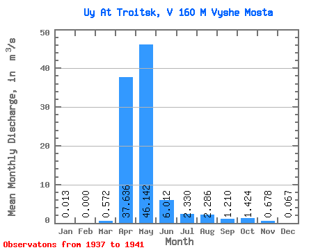
| Statistic | Jan | Feb | Mar | Apr | May | Jun | Jul | Aug | Sep | Oct | Nov | Dec | Annual |
|---|---|---|---|---|---|---|---|---|---|---|---|---|---|
| Mean | 0.01 | 0.00 | 0.57 | 37.64 | 46.14 | 6.01 | 2.33 | 2.29 | 1.21 | 1.42 | 0.68 | 0.07 | 8.20 |
| Standard Deviation | 0.03 | 0.00 | 1.27 | 29.40 | 92.17 | 7.34 | 1.75 | 2.36 | 1.43 | 1.45 | 0.59 | 0.09 | 11.15 |
| Min | 0.00 | 0.00 | 0.00 | 9.68 | 3.69 | 2.17 | 1.16 | 0.61 | 0.40 | 0.46 | 0.36 | 0.00 | 1.60 |
| Max | 0.06 | 0.00 | 2.84 | 85.00 | 211.00 | 19.10 | 5.41 | 6.20 | 3.75 | 4.00 | 1.72 | 0.21 | 28.03 |
| Coefficient of Variation | 2.24 | 2.22 | 0.78 | 2.00 | 1.22 | 0.75 | 1.03 | 1.18 | 1.02 | 0.86 | 1.33 | 1.36 |
 Return to R-Arctic Net Home Page