|
|
|||||||||||||||||
| Point ID: 8756 | Downloads | Plots | Site Data | Code: 12643 |
|
|
|||||||||||||||||
| Download | |
|---|---|
| Site Descriptor Information | Site Time Series Data |
| Link to all available data | |
| View: | Time Series | All |
| Units: | mm |
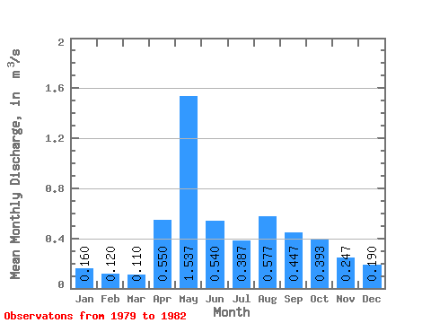
| Statistic | Jan | Feb | Mar | Apr | May | Jun | Jul | Aug | Sep | Oct | Nov | Dec | Annual |
|---|---|---|---|---|---|---|---|---|---|---|---|---|---|
| Mean | 0.16 | 0.12 | 0.11 | 0.55 | 1.54 | 0.54 | 0.39 | 0.58 | 0.45 | 0.39 | 0.25 | 0.19 | 0.37 |
| Standard Deviation | 0.03 | 0.00 | 0.01 | 0.41 | 0.78 | 0.23 | 0.14 | 0.57 | 0.13 | 0.16 | 0.09 | 0.05 | 0.08 |
| Min | 0.13 | 0.12 | 0.10 | 0.15 | 0.74 | 0.36 | 0.24 | 0.21 | 0.37 | 0.25 | 0.16 | 0.15 | 0.32 |
| Max | 0.18 | 0.12 | 0.12 | 0.97 | 2.61 | 0.86 | 0.51 | 1.23 | 0.60 | 0.57 | 0.34 | 0.25 | 0.43 |
| Coefficient of Variation | 0.17 | 0.00 | 0.09 | 0.75 | 0.51 | 0.42 | 0.35 | 0.98 | 0.30 | 0.41 | 0.37 | 0.28 | 0.22 |
 Return to R-Arctic Net Home Page