|
|
|||||||||||||||||
| Point ID: 8734 | Downloads | Plots | Site Data | Code: 12619 |
|
|
|||||||||||||||||
| Download | |
|---|---|
| Site Descriptor Information | Site Time Series Data |
| Link to all available data | |
| View: | Time Series | All |
| Units: | mm |
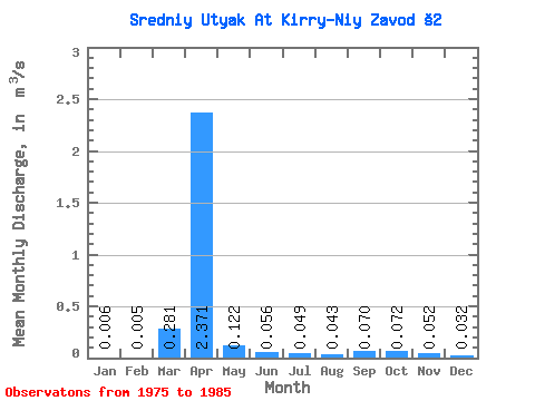
| Statistic | Jan | Feb | Mar | Apr | May | Jun | Jul | Aug | Sep | Oct | Nov | Dec | Annual |
|---|---|---|---|---|---|---|---|---|---|---|---|---|---|
| Mean | 0.01 | 0.01 | 0.28 | 2.37 | 0.12 | 0.06 | 0.05 | 0.04 | 0.07 | 0.07 | 0.05 | 0.03 | 0.26 |
| Standard Deviation | 0.01 | 0.01 | 0.64 | 1.72 | 0.06 | 0.03 | 0.04 | 0.03 | 0.07 | 0.05 | 0.03 | 0.02 | 0.18 |
| Min | 0.00 | 0.00 | 0.00 | 0.32 | 0.05 | 0.02 | 0.00 | 0.01 | 0.01 | 0.01 | 0.01 | 0.00 | 0.04 |
| Max | 0.02 | 0.04 | 2.05 | 4.93 | 0.24 | 0.11 | 0.13 | 0.12 | 0.26 | 0.18 | 0.09 | 0.06 | 0.61 |
| Coefficient of Variation | 1.30 | 2.56 | 2.27 | 0.73 | 0.45 | 0.52 | 0.80 | 0.73 | 1.05 | 0.64 | 0.62 | 0.76 | 0.70 |
 Return to R-Arctic Net Home Page