|
|
|||||||||||||||||
| Point ID: 8725 | Downloads | Plots | Site Data | Code: 12520 |
|
|
|||||||||||||||||
| Download | |
|---|---|
| Site Descriptor Information | Site Time Series Data |
| Link to all available data | |
| View: | Time Series | All |
| Units: | mm |
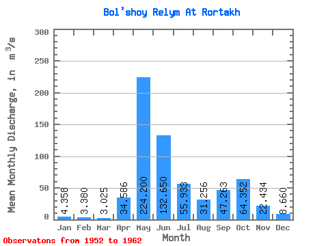
| Statistic | Jan | Feb | Mar | Apr | May | Jun | Jul | Aug | Sep | Oct | Nov | Dec | Annual |
|---|---|---|---|---|---|---|---|---|---|---|---|---|---|
| Mean | 4.36 | 3.38 | 3.02 | 34.59 | 224.20 | 132.65 | 55.93 | 31.26 | 47.26 | 64.35 | 22.43 | 8.66 | 56.15 |
| Standard Deviation | 1.68 | 1.06 | 0.76 | 31.20 | 49.69 | 34.23 | 44.67 | 43.94 | 53.89 | 71.21 | 19.40 | 7.68 | 22.33 |
| Min | 2.13 | 2.23 | 2.20 | 3.31 | 166.00 | 89.90 | 16.60 | 5.10 | 5.94 | 5.56 | 2.97 | 1.98 | 36.70 |
| Max | 6.67 | 4.94 | 4.24 | 70.20 | 271.00 | 179.00 | 138.00 | 128.00 | 162.00 | 149.00 | 50.70 | 21.20 | 84.25 |
| Coefficient of Variation | 0.39 | 0.32 | 0.25 | 0.90 | 0.22 | 0.26 | 0.80 | 1.41 | 1.14 | 1.11 | 0.86 | 0.89 | 0.40 |
 Return to R-Arctic Net Home Page