|
|
|||||||||||||||||
| Point ID: 8721 | Downloads | Plots | Site Data | Code: 12482 |
|
|
|||||||||||||||||
| Download | |
|---|---|
| Site Descriptor Information | Site Time Series Data |
| Link to all available data | |
| View: | Time Series | All |
| Units: | mm |
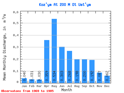
| Statistic | Jan | Feb | Mar | Apr | May | Jun | Jul | Aug | Sep | Oct | Nov | Dec | Annual |
|---|---|---|---|---|---|---|---|---|---|---|---|---|---|
| Mean | 0.04 | 0.03 | 0.03 | 0.36 | 0.53 | 0.30 | 0.27 | 0.20 | 0.20 | 0.19 | 0.09 | 0.06 | 0.17 |
| Standard Deviation | 0.01 | 0.01 | 0.02 | 0.18 | 0.37 | 0.17 | 0.25 | 0.20 | 0.20 | 0.14 | 0.03 | 0.02 | 0.01 |
| Min | 0.03 | 0.02 | 0.01 | 0.07 | 0.13 | 0.01 | 0.06 | 0.05 | 0.04 | 0.04 | 0.06 | 0.04 | 0.16 |
| Max | 0.05 | 0.04 | 0.05 | 0.67 | 1.30 | 0.58 | 0.83 | 0.81 | 0.87 | 0.43 | 0.12 | 0.10 | 0.18 |
| Coefficient of Variation | 0.26 | 0.33 | 0.55 | 0.49 | 0.69 | 0.57 | 0.94 | 1.03 | 1.03 | 0.73 | 0.33 | 0.34 | 0.07 |
 Return to R-Arctic Net Home Page