|
|
|||||||||||||||||
| Point ID: 8720 | Downloads | Plots | Site Data | Code: 12480 |
|
|
|||||||||||||||||
| Download | |
|---|---|
| Site Descriptor Information | Site Time Series Data |
| Link to all available data | |
| View: | Time Series | All |
| Units: | mm |
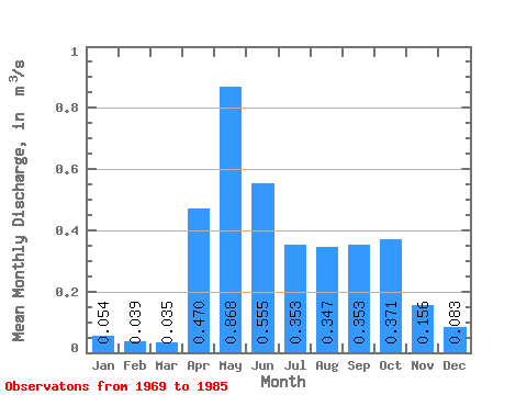
| Statistic | Jan | Feb | Mar | Apr | May | Jun | Jul | Aug | Sep | Oct | Nov | Dec | Annual |
|---|---|---|---|---|---|---|---|---|---|---|---|---|---|
| Mean | 0.05 | 0.04 | 0.04 | 0.47 | 0.87 | 0.56 | 0.35 | 0.35 | 0.35 | 0.37 | 0.16 | 0.08 | 0.30 |
| Standard Deviation | 0.02 | 0.01 | 0.01 | 0.36 | 0.64 | 0.34 | 0.31 | 0.40 | 0.31 | 0.26 | 0.09 | 0.04 | 0.07 |
| Min | 0.04 | 0.03 | 0.03 | 0.03 | 0.18 | 0.06 | 0.01 | 0.04 | 0.03 | 0.10 | 0.05 | 0.04 | 0.25 |
| Max | 0.10 | 0.06 | 0.04 | 1.01 | 2.02 | 1.16 | 1.16 | 1.27 | 1.24 | 0.84 | 0.32 | 0.16 | 0.40 |
| Coefficient of Variation | 0.45 | 0.31 | 0.20 | 0.77 | 0.74 | 0.61 | 0.88 | 1.16 | 0.87 | 0.71 | 0.60 | 0.46 | 0.23 |
 Return to R-Arctic Net Home Page