|
|
|||||||||||||||||
| Point ID: 872 | Downloads | Plots | Site Data | Code: 07EE010 |
|
|
|||||||||||||||||
| Download | |
|---|---|
| Site Descriptor Information | Site Time Series Data |
| Link to all available data | |
| View: | Time Series | All |
| Units: | mm |
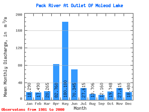
| Statistic | Jan | Feb | Mar | Apr | May | Jun | Jul | Aug | Sep | Oct | Nov | Dec | Annual |
|---|---|---|---|---|---|---|---|---|---|---|---|---|---|
| Mean | 18.29 | 17.49 | 20.27 | 82.76 | 180.10 | 70.34 | 27.61 | 13.71 | 12.16 | 19.75 | 27.61 | 18.48 | 42.38 |
| Standard Deviation | 6.96 | 5.03 | 8.68 | 33.18 | 37.09 | 32.68 | 12.23 | 6.26 | 6.98 | 11.48 | 17.90 | 4.55 | 7.46 |
| Min | 11.80 | 10.70 | 10.10 | 12.90 | 122.00 | 27.20 | 13.00 | 6.33 | 5.22 | 6.04 | 12.70 | 12.20 | 27.84 |
| Max | 34.30 | 28.50 | 49.90 | 145.00 | 279.00 | 133.00 | 61.80 | 25.50 | 35.20 | 42.20 | 89.30 | 27.40 | 57.94 |
| Coefficient of Variation | 0.38 | 0.29 | 0.43 | 0.40 | 0.21 | 0.47 | 0.44 | 0.46 | 0.57 | 0.58 | 0.65 | 0.25 | 0.18 |
 Return to R-Arctic Net Home Page