|
|
|||||||||||||||||
| Point ID: 87 | Downloads | Plots | Site Data | Code: 05AD006 |
|
|
|||||||||||||||||
| Download | |
|---|---|
| Site Descriptor Information | Site Time Series Data |
| Link to all available data | |
| View: | Time Series | All |
| Units: | mm |
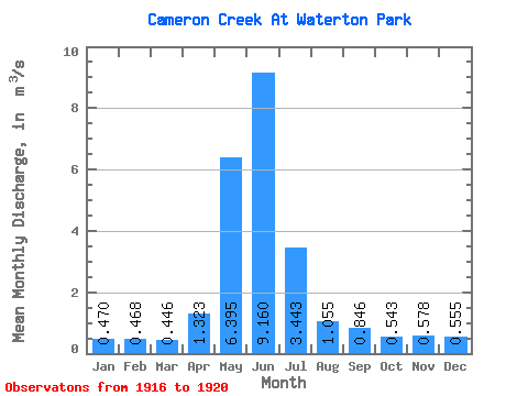
| Statistic | Jan | Feb | Mar | Apr | May | Jun | Jul | Aug | Sep | Oct | Nov | Dec | Annual |
|---|---|---|---|---|---|---|---|---|---|---|---|---|---|
| Mean | 0.47 | 0.47 | 0.45 | 1.32 | 6.39 | 9.16 | 3.44 | 1.05 | 0.85 | 0.54 | 0.58 | 0.56 | 2.11 |
| Standard Deviation | 0.19 | 0.17 | 0.20 | 0.72 | 2.49 | 4.32 | 2.32 | 0.47 | 0.60 | 0.17 | 0.22 | 0.33 | 0.66 |
| Min | 0.35 | 0.35 | 0.28 | 0.40 | 4.44 | 4.08 | 1.30 | 0.53 | 0.30 | 0.34 | 0.46 | 0.34 | 1.38 |
| Max | 0.81 | 0.77 | 0.78 | 1.91 | 10.00 | 12.80 | 6.22 | 1.67 | 1.67 | 0.72 | 0.91 | 1.04 | 2.68 |
| Coefficient of Variation | 0.41 | 0.36 | 0.45 | 0.54 | 0.39 | 0.47 | 0.67 | 0.45 | 0.71 | 0.31 | 0.38 | 0.60 | 0.31 |
 Return to R-Arctic Net Home Page