|
|
|||||||||||||||||
| Point ID: 8675 | Downloads | Plots | Site Data | Code: 11570 |
|
|
|||||||||||||||||
| Download | |
|---|---|
| Site Descriptor Information | Site Time Series Data |
| Link to all available data | |
| View: | Time Series | All |
| Units: | mm |
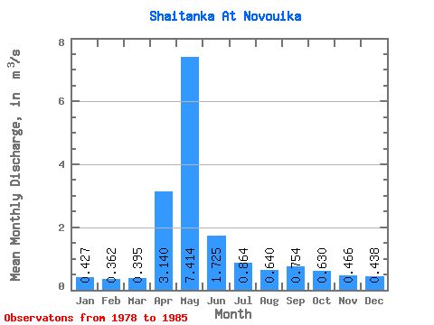
| Statistic | Jan | Feb | Mar | Apr | May | Jun | Jul | Aug | Sep | Oct | Nov | Dec | Annual |
|---|---|---|---|---|---|---|---|---|---|---|---|---|---|
| Mean | 0.43 | 0.36 | 0.40 | 3.14 | 7.41 | 1.73 | 0.86 | 0.64 | 0.75 | 0.63 | 0.47 | 0.44 | 1.33 |
| Standard Deviation | 0.12 | 0.11 | 0.09 | 2.06 | 4.91 | 0.96 | 0.29 | 0.12 | 0.49 | 0.03 | 0.14 | 0.15 | 0.81 |
| Min | 0.25 | 0.21 | 0.26 | 0.85 | 1.27 | 0.64 | 0.45 | 0.55 | 0.43 | 0.59 | 0.25 | 0.27 | 0.76 |
| Max | 0.58 | 0.50 | 0.52 | 6.32 | 14.50 | 3.19 | 1.20 | 0.85 | 1.61 | 0.66 | 0.62 | 0.62 | 1.91 |
| Coefficient of Variation | 0.28 | 0.30 | 0.24 | 0.66 | 0.66 | 0.56 | 0.34 | 0.19 | 0.65 | 0.05 | 0.31 | 0.33 | 0.61 |
 Return to R-Arctic Net Home Page