|
|
|||||||||||||||||
| Point ID: 8659 | Downloads | Plots | Site Data | Code: 11485 |
|
|
|||||||||||||||||
| Download | |
|---|---|
| Site Descriptor Information | Site Time Series Data |
| Link to all available data | |
| View: | Time Series | All |
| Units: | mm |
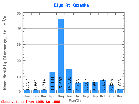
| Statistic | Jan | Feb | Mar | Apr | May | Jun | Jul | Aug | Sep | Oct | Nov | Dec | Annual |
|---|---|---|---|---|---|---|---|---|---|---|---|---|---|
| Mean | 1.94 | 1.66 | 1.71 | 13.18 | 45.99 | 14.60 | 6.08 | 6.59 | 6.65 | 8.22 | 5.03 | 2.63 | 9.51 |
| Standard Deviation | 0.65 | 0.45 | 0.47 | 9.60 | 24.47 | 4.59 | 2.26 | 4.45 | 4.25 | 4.58 | 2.13 | 0.91 | 2.73 |
| Min | 0.63 | 0.52 | 0.85 | 3.23 | 12.80 | 9.24 | 2.78 | 1.46 | 1.52 | 3.11 | 1.99 | 1.10 | 5.82 |
| Max | 3.47 | 2.47 | 2.76 | 34.60 | 92.10 | 24.20 | 10.70 | 15.30 | 14.80 | 15.10 | 8.12 | 4.62 | 15.99 |
| Coefficient of Variation | 0.34 | 0.27 | 0.27 | 0.73 | 0.53 | 0.32 | 0.37 | 0.68 | 0.64 | 0.56 | 0.42 | 0.35 | 0.29 |
 Return to R-Arctic Net Home Page