|
|
|||||||||||||||||
| Point ID: 8657 | Downloads | Plots | Site Data | Code: 11473 |
|
|
|||||||||||||||||
| Download | |
|---|---|
| Site Descriptor Information | Site Time Series Data |
| Link to all available data | |
| View: | Time Series | All |
| Units: | mm |
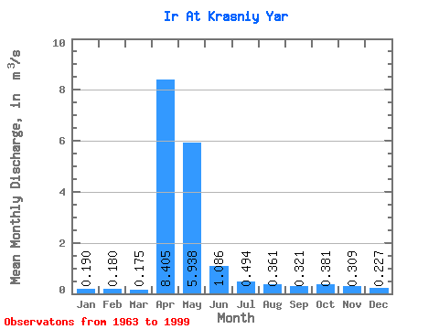
| Statistic | Jan | Feb | Mar | Apr | May | Jun | Jul | Aug | Sep | Oct | Nov | Dec | Annual |
|---|---|---|---|---|---|---|---|---|---|---|---|---|---|
| Mean | 0.19 | 0.18 | 0.17 | 8.40 | 5.94 | 1.09 | 0.49 | 0.36 | 0.32 | 0.38 | 0.31 | 0.23 | 1.52 |
| Standard Deviation | 0.07 | 0.07 | 0.07 | 6.14 | 6.28 | 0.92 | 0.44 | 0.30 | 0.17 | 0.23 | 0.16 | 0.09 | 0.88 |
| Min | 0.03 | 0.01 | 0.00 | 1.08 | 0.41 | 0.21 | 0.17 | 0.13 | 0.14 | 0.12 | 0.03 | 0.10 | 0.26 |
| Max | 0.32 | 0.30 | 0.30 | 25.60 | 29.70 | 3.88 | 2.13 | 1.81 | 0.83 | 1.12 | 0.64 | 0.46 | 3.15 |
| Coefficient of Variation | 0.37 | 0.40 | 0.41 | 0.73 | 1.06 | 0.84 | 0.90 | 0.84 | 0.52 | 0.59 | 0.50 | 0.38 | 0.58 |
 Return to R-Arctic Net Home Page