|
|
|||||||||||||||||
| Point ID: 8656 | Downloads | Plots | Site Data | Code: 11472 |
|
|
|||||||||||||||||
| Download | |
|---|---|
| Site Descriptor Information | Site Time Series Data |
| Link to all available data | |
| View: | Time Series | All |
| Units: | mm |
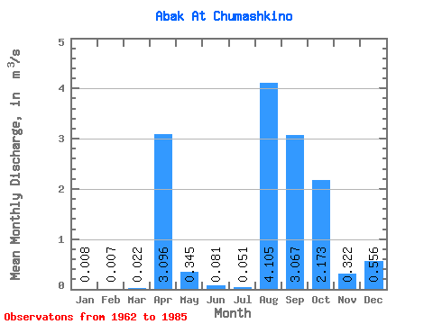
| Statistic | Jan | Feb | Mar | Apr | May | Jun | Jul | Aug | Sep | Oct | Nov | Dec | Annual |
|---|---|---|---|---|---|---|---|---|---|---|---|---|---|
| Mean | 0.01 | 0.01 | 0.02 | 3.10 | 0.34 | 0.08 | 0.05 | 4.11 | 3.07 | 2.17 | 0.32 | 0.56 | 0.31 |
| Standard Deviation | 0.01 | 0.01 | 0.02 | 2.07 | 0.51 | 0.10 | 0.07 | 20.00 | 14.90 | 10.40 | 1.42 | 2.65 | 0.20 |
| Min | 0.00 | 0.00 | 0.00 | 0.48 | 0.04 | 0.02 | 0.00 | 0.00 | 0.00 | 0.01 | 0.01 | 0.00 | 0.06 |
| Max | 0.03 | 0.03 | 0.10 | 8.36 | 2.37 | 0.46 | 0.25 | 98.00 | 73.00 | 51.00 | 7.00 | 13.00 | 0.85 |
| Coefficient of Variation | 0.87 | 1.19 | 1.11 | 0.67 | 1.48 | 1.18 | 1.37 | 4.87 | 4.86 | 4.79 | 4.42 | 4.77 | 0.62 |
 Return to R-Arctic Net Home Page