|
|
|||||||||||||||||
| Point ID: 8646 | Downloads | Plots | Site Data | Code: 11395 |
|
|
|||||||||||||||||
| Download | |
|---|---|
| Site Descriptor Information | Site Time Series Data |
| Link to all available data | |
| View: | Time Series | All |
| Units: | mm |
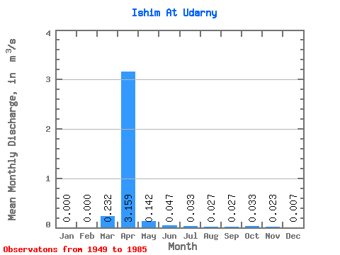
| Statistic | Jan | Feb | Mar | Apr | May | Jun | Jul | Aug | Sep | Oct | Nov | Dec | Annual |
|---|---|---|---|---|---|---|---|---|---|---|---|---|---|
| Mean | 0.00 | 0.00 | 0.23 | 3.16 | 0.14 | 0.05 | 0.03 | 0.03 | 0.03 | 0.03 | 0.02 | 0.01 | 0.31 |
| Standard Deviation | 0.00 | 0.00 | 0.68 | 2.79 | 0.12 | 0.03 | 0.02 | 0.01 | 0.01 | 0.01 | 0.01 | 0.01 | 0.24 |
| Min | 0.00 | 0.00 | 0.00 | 0.21 | 0.04 | 0.02 | 0.01 | 0.01 | 0.01 | 0.01 | 0.00 | 0.00 | 0.04 |
| Max | 0.00 | 0.01 | 3.94 | 11.70 | 0.57 | 0.13 | 0.10 | 0.06 | 0.06 | 0.07 | 0.04 | 0.02 | 1.01 |
| Coefficient of Variation | 6.08 | 2.91 | 0.89 | 0.83 | 0.55 | 0.60 | 0.42 | 0.35 | 0.38 | 0.49 | 1.06 | 0.76 |
 Return to R-Arctic Net Home Page