|
|
|||||||||||||||||
| Point ID: 8622 | Downloads | Plots | Site Data | Code: 11248 |
|
|
|||||||||||||||||
| Download | |
|---|---|
| Site Descriptor Information | Site Time Series Data |
| Link to all available data | |
| View: | Time Series | All |
| Units: | mm |
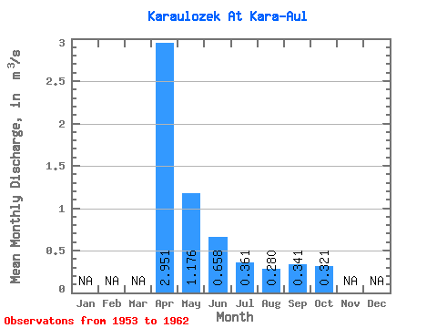
| Statistic | Jan | Feb | Mar | Apr | May | Jun | Jul | Aug | Sep | Oct | Nov | Dec | Annual |
|---|---|---|---|---|---|---|---|---|---|---|---|---|---|
| Mean | 2.95 | 1.18 | 0.66 | 0.36 | 0.28 | 0.34 | 0.32 | ||||||
| Standard Deviation | 1.11 | 1.11 | 0.57 | 0.18 | 0.12 | ||||||||
| Min | 2.02 | 0.25 | 0.05 | 0.15 | 0.17 | 0.34 | 0.32 | ||||||
| Max | 4.18 | 2.61 | 1.23 | 0.53 | 0.40 | 0.34 | 0.32 | ||||||
| Coefficient of Variation | 0.38 | 0.94 | 0.86 | 0.49 | 0.41 |
 Return to R-Arctic Net Home Page