|
|
|||||||||||||||||
| Point ID: 8621 | Downloads | Plots | Site Data | Code: 11247 |
|
|
|||||||||||||||||
| Download | |
|---|---|
| Site Descriptor Information | Site Time Series Data |
| Link to all available data | |
| View: | Time Series | All |
| Units: | mm |
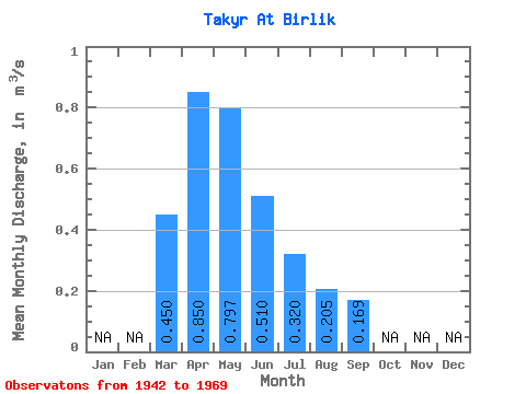
| Statistic | Jan | Feb | Mar | Apr | May | Jun | Jul | Aug | Sep | Oct | Nov | Dec | Annual |
|---|---|---|---|---|---|---|---|---|---|---|---|---|---|
| Mean | 0.45 | 0.85 | 0.80 | 0.51 | 0.32 | 0.20 | 0.17 | ||||||
| Standard Deviation | 0.50 | 0.32 | 0.20 | 0.13 | 0.07 | ||||||||
| Min | 0.45 | 0.85 | 0.20 | 0.12 | 0.04 | 0.04 | 0.09 | ||||||
| Max | 0.45 | 0.85 | 1.70 | 1.04 | 0.73 | 0.43 | 0.25 | ||||||
| Coefficient of Variation | 0.63 | 0.63 | 0.63 | 0.64 | 0.43 |
 Return to R-Arctic Net Home Page