|
|
|||||||||||||||||
| Point ID: 8620 | Downloads | Plots | Site Data | Code: 11246 |
|
|
|||||||||||||||||
| Download | |
|---|---|
| Site Descriptor Information | Site Time Series Data |
| Link to all available data | |
| View: | Time Series | All |
| Units: | mm |
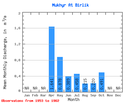
| Statistic | Jan | Feb | Mar | Apr | May | Jun | Jul | Aug | Sep | Oct | Nov | Dec | Annual |
|---|---|---|---|---|---|---|---|---|---|---|---|---|---|
| Mean | 1.64 | 0.88 | 0.39 | 0.46 | 0.21 | 0.22 | 0.49 | ||||||
| Standard Deviation | 0.55 | 0.70 | 0.25 | 0.20 | 0.14 | 0.23 | |||||||
| Min | 1.23 | 0.03 | 0.11 | 0.27 | 0.07 | 0.06 | 0.49 | ||||||
| Max | 2.27 | 1.78 | 0.76 | 0.65 | 0.41 | 0.38 | 0.49 | ||||||
| Coefficient of Variation | 0.34 | 0.80 | 0.65 | 0.44 | 0.67 | 1.03 |
 Return to R-Arctic Net Home Page