|
|
|||||||||||||||||
| Point ID: 8617 | Downloads | Plots | Site Data | Code: 11243 |
|
|
|||||||||||||||||
| Download | |
|---|---|
| Site Descriptor Information | Site Time Series Data |
| Link to all available data | |
| View: | Time Series | All |
| Units: | mm |
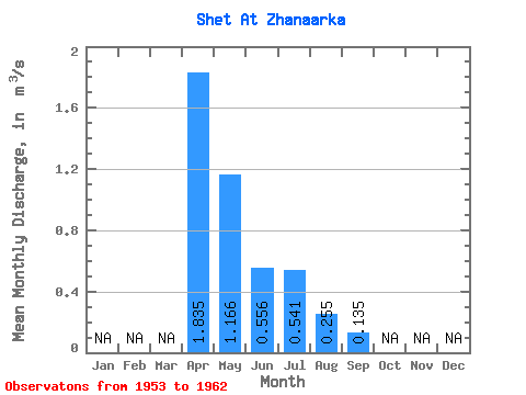
| Statistic | Jan | Feb | Mar | Apr | May | Jun | Jul | Aug | Sep | Oct | Nov | Dec | Annual |
|---|---|---|---|---|---|---|---|---|---|---|---|---|---|
| Mean | 1.83 | 1.17 | 0.56 | 0.54 | 0.26 | 0.14 | |||||||
| Standard Deviation | 0.56 | 0.67 | 0.48 | 0.30 | 0.14 | 0.02 | |||||||
| Min | 1.44 | 0.25 | 0.04 | 0.22 | 0.13 | 0.12 | |||||||
| Max | 2.23 | 2.09 | 1.33 | 0.95 | 0.44 | 0.15 | |||||||
| Coefficient of Variation | 0.30 | 0.57 | 0.87 | 0.56 | 0.54 | 0.16 |
 Return to R-Arctic Net Home Page