|
|
|||||||||||||||||
| Point ID: 859 | Downloads | Plots | Site Data | Code: 07EB002 |
|
|
|||||||||||||||||
| Download | |
|---|---|
| Site Descriptor Information | Site Time Series Data |
| Link to all available data | |
| View: | Time Series | All |
| Units: | mm |
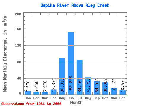
| Statistic | Jan | Feb | Mar | Apr | May | Jun | Jul | Aug | Sep | Oct | Nov | Dec | Annual |
|---|---|---|---|---|---|---|---|---|---|---|---|---|---|
| Mean | 7.97 | 6.47 | 5.98 | 12.37 | 90.31 | 152.82 | 84.16 | 41.73 | 34.01 | 30.06 | 16.14 | 10.67 | 41.06 |
| Standard Deviation | 1.53 | 1.00 | 1.01 | 4.89 | 35.96 | 38.60 | 27.04 | 11.59 | 12.17 | 12.15 | 5.00 | 2.73 | 5.06 |
| Min | 5.15 | 3.66 | 3.01 | 5.81 | 37.50 | 77.50 | 46.70 | 23.40 | 17.70 | 9.84 | 6.60 | 5.64 | 32.85 |
| Max | 10.90 | 8.04 | 8.10 | 25.90 | 159.00 | 210.00 | 159.00 | 61.50 | 58.10 | 61.40 | 29.00 | 15.70 | 49.66 |
| Coefficient of Variation | 0.19 | 0.15 | 0.17 | 0.40 | 0.40 | 0.25 | 0.32 | 0.28 | 0.36 | 0.40 | 0.31 | 0.26 | 0.12 |
 Return to R-Arctic Net Home Page