|
|
|||||||||||||||||
| Point ID: 8581 | Downloads | Plots | Site Data | Code: 11160 |
|
|
|||||||||||||||||
| Download | |
|---|---|
| Site Descriptor Information | Site Time Series Data |
| Link to all available data | |
| View: | Time Series | All |
| Units: | mm |
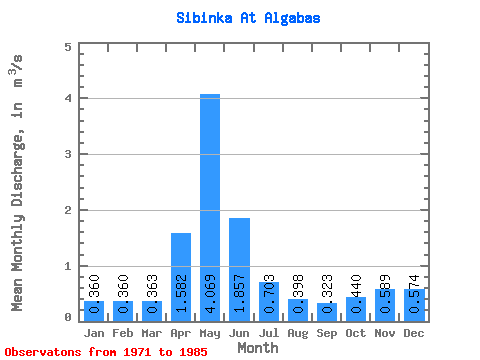
| Statistic | Jan | Feb | Mar | Apr | May | Jun | Jul | Aug | Sep | Oct | Nov | Dec | Annual |
|---|---|---|---|---|---|---|---|---|---|---|---|---|---|
| Mean | 0.36 | 0.36 | 0.36 | 1.58 | 4.07 | 1.86 | 0.70 | 0.40 | 0.32 | 0.44 | 0.59 | 0.57 | 1.20 |
| Standard Deviation | 0.21 | 0.20 | 0.15 | 0.78 | 1.86 | 1.27 | 0.44 | 0.22 | 0.14 | 0.28 | 0.30 | 0.44 | 0.51 |
| Min | 0.15 | 0.18 | 0.21 | 0.57 | 1.29 | 0.17 | 0.10 | 0.09 | 0.11 | 0.15 | 0.25 | 0.26 | 0.63 |
| Max | 0.72 | 0.69 | 0.65 | 2.81 | 7.12 | 3.88 | 1.62 | 0.93 | 0.65 | 1.07 | 1.08 | 1.46 | 1.58 |
| Coefficient of Variation | 0.60 | 0.54 | 0.42 | 0.49 | 0.46 | 0.69 | 0.63 | 0.55 | 0.44 | 0.63 | 0.51 | 0.76 | 0.42 |
 Return to R-Arctic Net Home Page