|
|
|||||||||||||||||
| Point ID: 8573 | Downloads | Plots | Site Data | Code: 11138 |
|
|
|||||||||||||||||
| Download | |
|---|---|
| Site Descriptor Information | Site Time Series Data |
| Link to all available data | |
| View: | Time Series | All |
| Units: | mm |
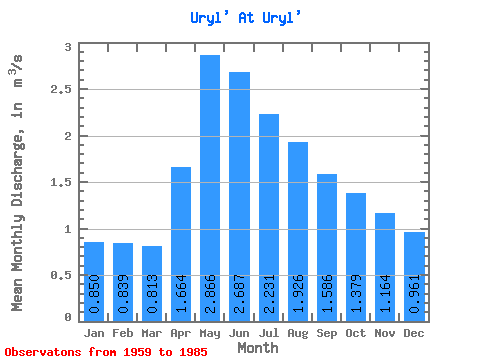
| Statistic | Jan | Feb | Mar | Apr | May | Jun | Jul | Aug | Sep | Oct | Nov | Dec | Annual |
|---|---|---|---|---|---|---|---|---|---|---|---|---|---|
| Mean | 0.85 | 0.84 | 0.81 | 1.66 | 2.87 | 2.69 | 2.23 | 1.93 | 1.59 | 1.38 | 1.16 | 0.96 | 1.58 |
| Standard Deviation | 0.21 | 0.22 | 0.21 | 0.58 | 0.97 | 1.23 | 0.91 | 0.79 | 0.56 | 0.41 | 0.39 | 0.28 | 0.45 |
| Min | 0.51 | 0.57 | 0.53 | 0.76 | 1.35 | 1.11 | 1.09 | 0.95 | 0.88 | 0.76 | 0.65 | 0.53 | 1.01 |
| Max | 1.42 | 1.42 | 1.43 | 3.01 | 4.84 | 5.94 | 4.44 | 4.62 | 3.62 | 2.81 | 2.53 | 1.87 | 2.75 |
| Coefficient of Variation | 0.25 | 0.27 | 0.25 | 0.35 | 0.34 | 0.46 | 0.41 | 0.41 | 0.35 | 0.30 | 0.34 | 0.29 | 0.28 |
 Return to R-Arctic Net Home Page